tester

Verwendung von Cookies

Wir verwenden Cookies, um Ihnen die Navigation auf unserer Website komfortabler zu machen und sie zu analysieren. Sie können alle akzeptieren, ablehnen oder durch Drücken der entsprechenden Schaltflächen Ihre individuellen Einstellungen vornehmen. Bitte beachten Sie, dass das Ablehnen von Cookies Ihr Navigationserlebnis beeinträchtigen kann. Weitere Informationen finden Sie in unserer Cookie-Richtlinie.

Cookies konfigurieren

Cookies sind ein wesentlicher Bestandteil der Funktionsweise unserer Website. Der Hauptzweck von Cookies besteht darin, Ihr Surferlebnis komfortabler und effizienter zu gestalten sowie unsere Dienstleistungen und die Website selbst weiter zu verbessern. Hier erhalten Sie alle Informationen über die von uns verwendeten Cookies und können diese nach Ihren Wünschen aktivieren oder deaktivieren. Davon ausgenommen sind solche Cookies, die für den Betrieb der Website unbedingt erforderlich sind. Bei einigen Cookies kann Ihr Erlebnis auf der Website und deren Betrieb beeinträchtigt werden, wenn Sie diese deaktivieren. Weitere Informationen finden Sie in unserer Cookie-Richtlinie.

Unbedingt (technisch) notwendige Cookies

Diese Cookies sind für das Funktionieren der Website unerlässlich und können in unseren Systemen nicht deaktiviert werden. Sie bilden im Allgemeinen die Grundlage solcher Aktionen, die Sie auf unserer Website durchführen können, also etwa Dienstleistungen bestellen, Ihre Datenschutzeinstellungen festlegen, sich Anmelden oder Formulare ausfüllen. Sie können Ihren Webbrowser so einstellen, dass er diese Cookies blockiert oder Sie auf sie hinweist, doch einige Teile der Website funktionieren nicht, wenn sie blockiert werden. Informationen zu Cookies

Analytische Cookies

Anhand dieser Cookies können wir die Besuche zählen und Traffic-Quellen bestimmen. Damit messen wir die Leistung unserer Website und können sie verbessern. Sie helfen uns herauszufinden, welche Seiten am beliebtesten und welche am wenigsten beliebt sind, und wir können sehen, wie sich die Besucher auf der Website bewegen. Alle von diesen Cookies gesammelten Daten werden aggregiert und sind daher anonym. Wenn Sie diese Cookies nicht zulassen, erfahren wir nicht, wann Sie unsere Website besucht haben. Informationen zu Cookies

Cookies an Dritte

Diese Cookies werden zur Analyse Ihrer Aktivitäten verwendet, um Ihnen personalisierte Werbung zu zeigen. Informationen zu Cookies

Akzeptieren Ablehnen Cookies konfigurieren Auswahl bestätigen
Suche
×
Anmerkungen
Suche
Keine Notizen
  • Libro digital
  • Um Stift anzupassen, drücken Sie Alt + Pfeil nach unten
  • Um Textmarker anzupassen, drücken Sie Alt + Pfeil nach unten

    Thema ändern

    Fehler - Bitte überprüfen Sie Ihre Internetverbindung...
    Zurück

    Blink Help

    x
    Fehler - Bitte überprüfen Sie Ihre Internetverbindung...

    Wie können wir Ihnen helfen?

    Keine Ergebnisse

    Vollständiges Handbuch ansehen

    Sie konnten das Gesuchte nicht finden?

    Beschreiben Sie Ihre Frage so detailliert wie möglich. Geben Sie uns die Klasse, das Zugangsgerät, den Lizenzcode, den betroffenen Benutzer und Browser an oder ob es Ihnen in der App passiert:

    Dicke:
    Textgröße:
    Filter
      keine Ressourcen zugeordnet
      Textgröße:
      Überprüfungsmodus

      Überprüfungsmodus

      Libro digital
      2. Representing the Earth
      Ohne Hintergrundton
      Logo

      Plans

      Plans are used to show the distribution or location of objects in a space or to indicate where buildings or places are located.
      A town plan shows the location of houses, buildings, parks, etc, over a geographical area.

      • Orthogonal checkerboard plans are usually used in cities where the streets are arranged in orderly, straight, parallel lines.
      • Radiocentric plans are used in cities or towns which have circular avenues or streets that lead to a common point in the city.
      • Linear plans show elongated places, usually near motorways or main roads.
      • Irregular plans usually show smaller towns or villages which do not have a definite structure.

      An orthogonal plan.

      A radiocentric plan.

      A linear plan.

      An irregular plan.

      The cardinal points

      A compass rose shows the four cardinal points: north, south, east and west. This helps us orient the objects on a map.

      Symbols and legends

      Many plans use symbols to show different landmarks and places. A symbol is a picture which represents something in the real world. We need to have a map key or a legend.

      The scale and toponymy

      Maps also have a scale. Maps are smaller than the real-life places they portray, but they maintain the same proportion. For example, one kilometre in real-life is shown as one centimetre on a map.
      All the names of the different places on a map are called the toponymy of that place.

      Libro digital
      2. Representing the Earth
      Ohne Hintergrundton
      Logo

      Maps

      A map is a representation of the Earth's surface, which shows how landmarks are related to each other by distance, direction and size.
      Maps must show a round area (because the Earth is a sphere) on a flat surface. Because of this, maps often have distortion; objects closer to the Equator have less distortion that objects that are further away.
      There are three main types of maps:

      Physical maps: These show the physical features of an area (mountains, rivers, lakes...). Colour is used to show relief or land elevation in the landscape.

      Political maps: These show national and state boundaries and important cities.


      Thematic maps: There are different kinds of thematic maps.

      • Topographic maps: show Earth in two dimensions using contour lines. Lines close together show steep terrain and lines far apart show flat terrain.
      • Climate maps: give us information about the climate and precipitation (rain, snow, etc.) in a region.
      • Road and street maps: show the motorways and streets in smaller areas such as towns and cities.


      1. Which map (a-e) would you need to find out information about...

      1 ... a country's borders? 

      2 ... a country's weather?

      3 ... places in a town? 

      4 ... a country's geography?

      5 ... whether an area is flat or steep?

      →

      →

      →

      →

      →

      1. In your own words, explain what distortion is and why it occurs.

      Libro digital
      2. Representing the Earth
      Ohne Hintergrundton
      Logo

      Map scales

      Maps are visual representations of real-life landscapes. Map scales show the difference between the distance on the map and the distance in real-life. The two types of scale are:

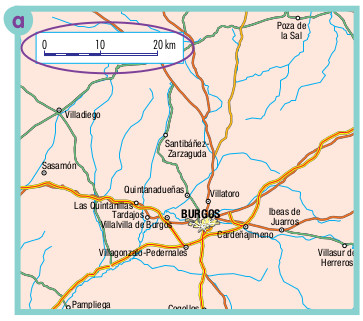
      • The graphic scale shows scale using a line with separated sections. One side represents the distance on the map. The other side represents the real-life distance. You measure the distance between two objects on the map. Then you compare it with the distance on the scale.
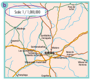
      • The fractional scale uses fractions to describe the ratio between distances on the map and the real world. One unit on the map equals 1,000 units of distance in the real world, eg. 1 centimetre equals 1,000 centimetres (1,000 cm = 10 m) in real life. The fraction is shown as 1:1,000 or 1/1,000.

      A graphic scale.

      A fractional scale.

      Small scale and large scale maps

      Maps can be small or large scale. 

      • Small scale maps show a large area. They are called small scale because objects are very small. They can show a whole country but little detail.

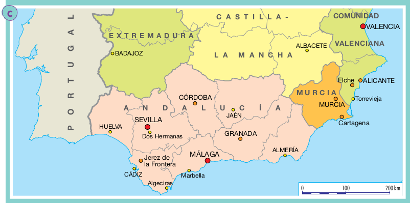
      • Large scale maps show a smaller area but in more detail. It shows the objects and landmarks on the map. You can see more details on this map of Malaga than the map of Spain.

      A small scale map of Spain

      A large scale map of Malaga

      Globes and world maps

      The Earth is a three-dimensional sphere but a map is only two-dimensional. We use three-dimensional globes to show the Earth more accurately. On both globes and maps there are lines of longitude and latitude. These are imaginary lines that help us locate different places on the Earth.

      The most important line of longitude is called the Prime Meridian. It passes trough  Greenwich,  and  is sometimes know as the Greenwich Merididan.
      The most important line of latitude is the Equator which divides the Earth into the Northern  and  Southern hemispheres.

      We measure the latitude of a specific place depending on whether it is north or south of the  Equator. Longitude is measured in terms of east and west.
      On the globe you can also see the North Pole and the South Pole. This is where the Earth's  axis  passes through. If you look at the globe you can see that it is tilted to show the real-life  tilting and  rotation of the Earth.                      


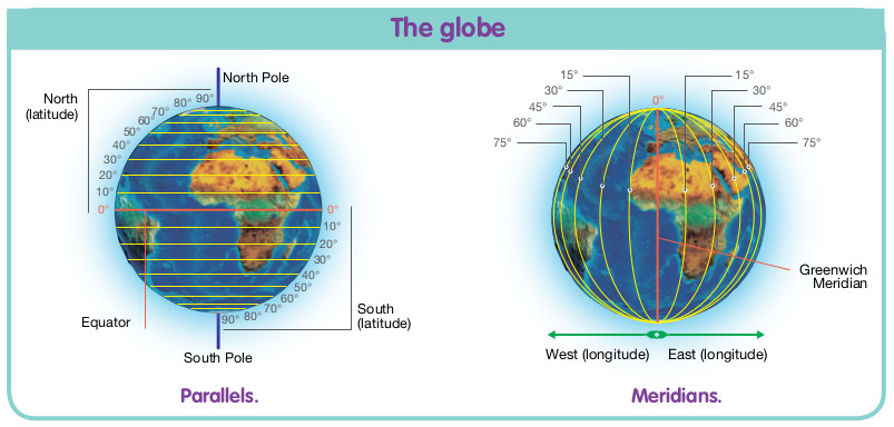
      A map of the world showing lines of latitude and longitude.

      1. Look at map a. How far is it from Villadiego to Quintanadueñas?

      1. Look at map b. How far is it from Villadiego to Pozo de la Sal?

      1. Try to answer the following questions without a calculator.

      1 How many metres are there in two kilometres?

      2 How many centimetres are there in one kilometre? 

      3 30,500 metres equal how many kilometres?

      4 How many centimetres are there in 16 kilometres?

      1. Draw a graphic and fractional scale to represent the following distances.

      1 One centimetre represents ten kilometres.

      2 One centimetre represents forty kilometres.

      1. Work with a partner. Take turns asking your partner to calculate two distances. You can use the maps above or a different map.

      1. Look at map c. How far is it from Cádiz to Jaén?

      1. Look at map d. What is the approximate distance between the two statues?

      Which map should I use?

      These people need to find the right type of map for them. Listen to their needs, then match the person to the correct type of map.

      1 Deena, a tourist in Granada.

      2 Joe, a student learning about European capital cities.

      3 Hillary, a hiker in the Sierra Nevada.

      4 Jamal, a kayaker who wants to learn about bodies of 

      water and natural landscape in Spain.

      →

      →

      →

      →


      Libro digital
      2. Representing the Earth
      Ohne Hintergrundton
      Logo

      Apply your skills!

      Project 1: Where do we come from?

      From wide and far, here we all are!

      Connect your photo to your family's country (or countries) of origin with wool using tape. Your map should look like the example below.

      Libro digital
      2. Representing the Earth
      Ohne Hintergrundton
      Logo

      Check what you know!

      1. Are these sentences True or False?

      Fertig
      Libro digital
      2. Representing the Earth
      Ohne Hintergrundton
      Logo

      Check what you know!

      1. Match each type of map to its example. When should we use each type of map?

      • a

      • b

      • c

      • d

      • e

      • f

      • Thematic map

      • Road map

      • Topographic map

      • Physical map

      • Political map

      • Climate map

      Fertig

      ,
      Sie haben die Einheit beendet.

      Unten sehen Sie, wie viel Zeit Sie gebraucht und welche Punktzahl Sie erreicht haben.

      Zeit

      Punktzahl

      1. 1
      2. 2
      3. 3
      4. 4
      5. 5
      6. 6
        Radiergummi
        Rich-Text-Editor
        Schließen